
Windy Hill

Portola Valley, CA – Midpeninsula Regional Open Space District

Last updated on January 7th, 2026 at 5:37 pm

Important Notice: Rangers have recently been issuing citations for landing on MROSD propert ouytside of Windy Hill Open Space Preserve. Rangers may cite you with a misdemeanor, which may result in a large fine, jail time, and deportation.

Quick Overview:

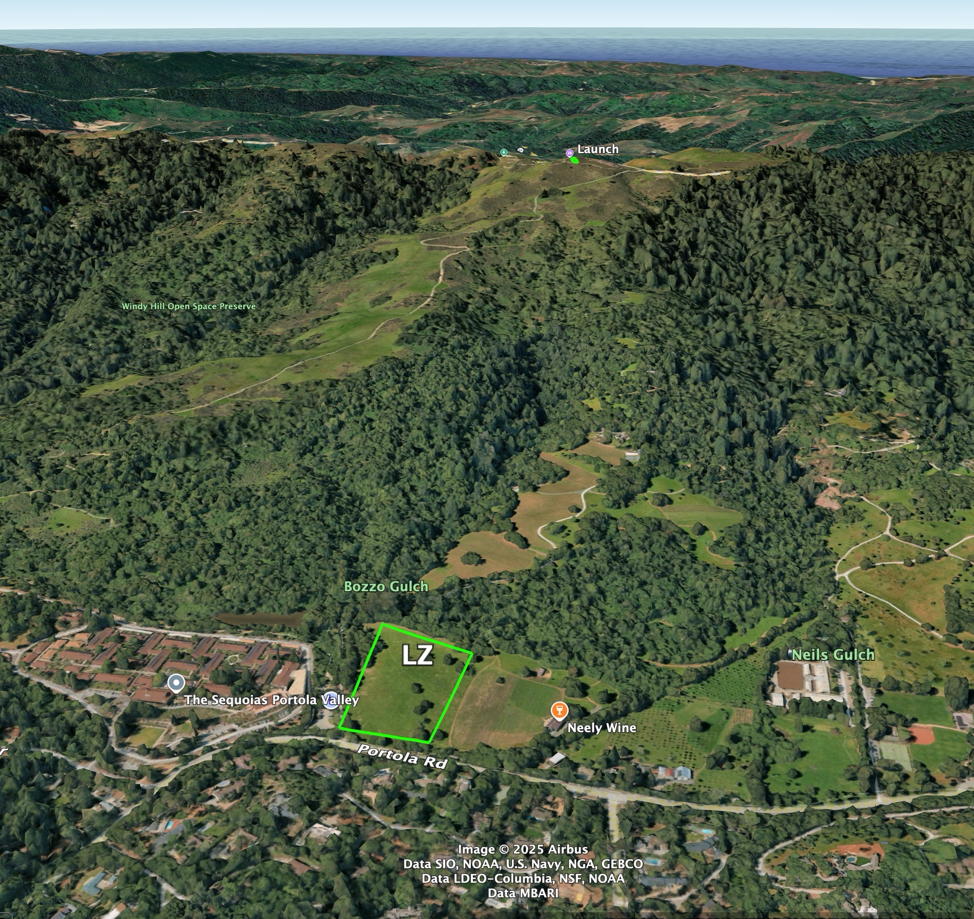
Windy Hill is a Northeast-facing paragliding and hang gliding site on Midpeninsula Regional Open Space District land, and requires excellent pilot judgement and skills in order to be flown safely. It is the most technical site in the Bay Area due to the long glide to the LZ, confined LZ, and frequent strong wind at launch. Windy Hill is a great place to hike and fly and offers the ability to drive close to launch and the LZ.

Telegram

Radio Frequency: 147.405 MHz

Site Committee Chairs: Tom Low & Evan Cohen

[email protected]

Hang gliding: H4
Paragliding: P4
Mini-wings: discouraged due to their poor gliding performance

Park Information

Club Rules

  • Current USHPA and WOR (full or visiting) membership
  • Follow all park rules and regulations
  • Follow all FAR part 103 operating requirements
  • Fly with a helmet and an emergency parachute
  • Meet all rating requirements
  • Launch only from a designed launch
  • Land only in a designated LZ unless top landing
  • Call 911 in case of an emergency
  • No commercial activity
  • Report any accidents, incidents or concerns using this form
  • Recommended to fly with a cell phone, radio and satellite tracker

Site Requirements

  • All pilots must have a special use permit from the Midpeninsula Regional Open Space District
  • Pilots must sign-in before flying
  • Pilots must receive a site intro from a pilot who has significant experience flying at Windy Hill
  • There can be no more than ten gliders present in the preserve at any time, and no more than five at launch
  • Flying is prohibited on Independence Day, Memorial Day, and Labor Day

How To Get A Permit

Note: The MROSD has temporarily suspended issuing new permits.  Pilots with current permits may continue to fly at Windy Hill.

Please only request a permit after meeting all of the requirements above, after reading through the site guide, and after visiting Windy Hill on foot and determining that you have the skills to be able to fly there safely. Pilots must demonstrate that they have the technical and decision making skills to safely land in a restricted landing field. If you are not confident in your ability to do this, please do not fly at Windy Hill, for your own safety, and in the interest of preserving the site.

Request a permit by sending an email to [email protected] and include the following information: Your name, USHPA number, USHPA Expiration Date.

This information will be forwarded to the MROSD permit office on your behalf, and will be retained in the MROSD’s systems according to the their data retention policies, not WOR’s.

The MROSD has a few days up to several weeks turn-around time for issuing permits, depending on office staff availability. Request a permit before you fly. Be patient, and do not expect to fly on the same day that you request your permit.
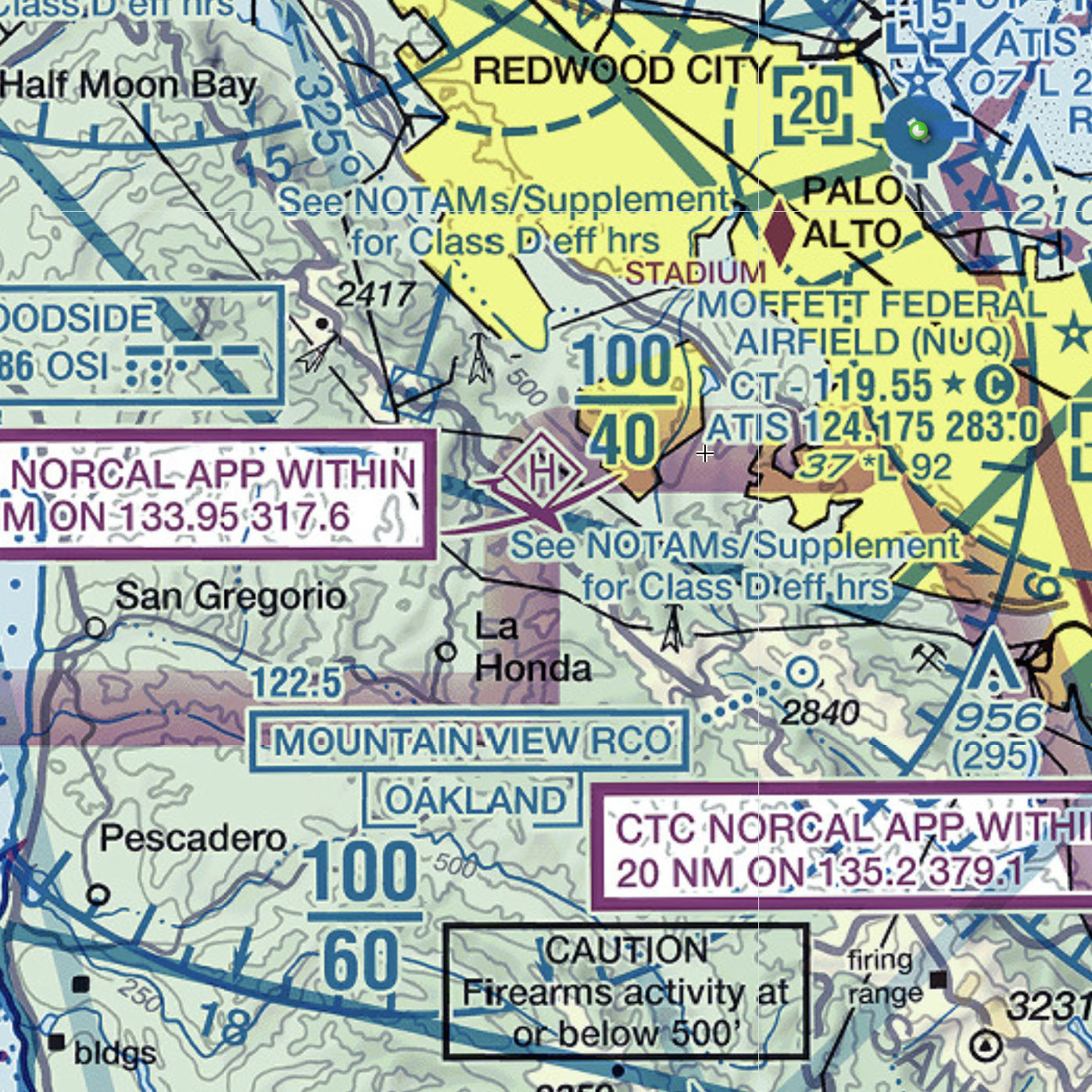
Airspace

  • Maximum altitude over Windy Hill is 4000′
  • Restricted altitude increases to 6000′ to the south
  • Windy Hill is in close proximity to 3 small airports (Palo Alto, San Carlos, and Half Moon Bay), several hospitals with helipads, and it is also very close to the Woodside VOR
  • Significant general aviation and helicopter traffic—pilots must see-and-avoid and follow FAR 103 yielding rules
  • It is recommended to fly with an instrument that displays airspace info

Launch (1910′)

Winds: NNE-ENE

HG: 0-30mpg, ideal 10mph

PG: 0-20mph, ideal 8mph

Glide ratio: 6:1

  • The launch area at Windy Hill is at the summit of the mountain.  There is room beside and behind the bushes at the top to set up and stage hang gliders and paragliders
  • The launch area is only accessible on foot by hiking up the Anniversary Trail from the upper parking lot, or by hiking up the Betsy Crowder Trail, Spring Ridge Trail, and Anniversary Trails from the lower parking lot.
  • Beware of rotor downwind of the two large trees immediately in front of, and to the right of launch
  • There are 2 chain gates in the launch area to prevent hikers from using a bootleg trail and causing erosion. Pilots are allowed to temporarily take down the gates (clipped on with a carabiner) while launching. After the last pilot has launched, the gate must be put back up. Pilots must return to launch after flying to replace the gate, or may ask bystanders to replace the gate after the last pilot has launched.

Landing Zone (LZ)

  • The wind in the LZ is usually from the North or Northeast; setting up a downwind-base-final-approach is recommended for both PG and HG, however in very light or no-wind conditions, HGs may prefer to set up their landing approach to land uphill, and land to the West
  • The LZ is surrounded by high trees on 3 sides, and can be thermic in late Summer and Fall, which can result in challenging landing conditions for HGs, in particular
  • The LZ can remain wet and cold in the winter, especially 1-3 days after rain
  • Valley temperatures occasionally drop to below freezing at night. The LZ can produce strong sink under these conditions, especially later in the day when the sun is no longer heating the LZ. Pilots must be prepared for this, and for fast landings
  • The LZ slopes gently downwards from West to East
  • There is a fence and a winery on the North side of the LZ (the one side of the LZ that is not lined by high trees). Hang gliders must carefully set up their approaches, and be prepared to overshoot their desired landing spot if the LZ is thermic, and there is little to no headwind.
  • Be prepared for landing cross or downwind if a thermal is releasing from or near the LZ
  • Windy Hill is open to equestrians, and there are horse stables North of the LZ. Be mindful of this, when flying low, or coming in to land
  • The glide from launch to the LZ is shallow (6:1), and there is often a strong headwind up at launch that does not reliably produce lift
  • Lower-end paragliders (EN-A or low EN-B), and sometimes even higher end wings may have trouble safely reaching the LZ, especially if there is any sink near launch, or if the wind is crossed from the North
  • Though not official LZs, there are several viable PG-friendly bail-outs along the Spring Ridge trail that can be used in an emergency.  If you don’t think you are going to make the LZ, bail to the trail early, before the final committing glide over the canyon and winery, where there are no bailouts

Top landing

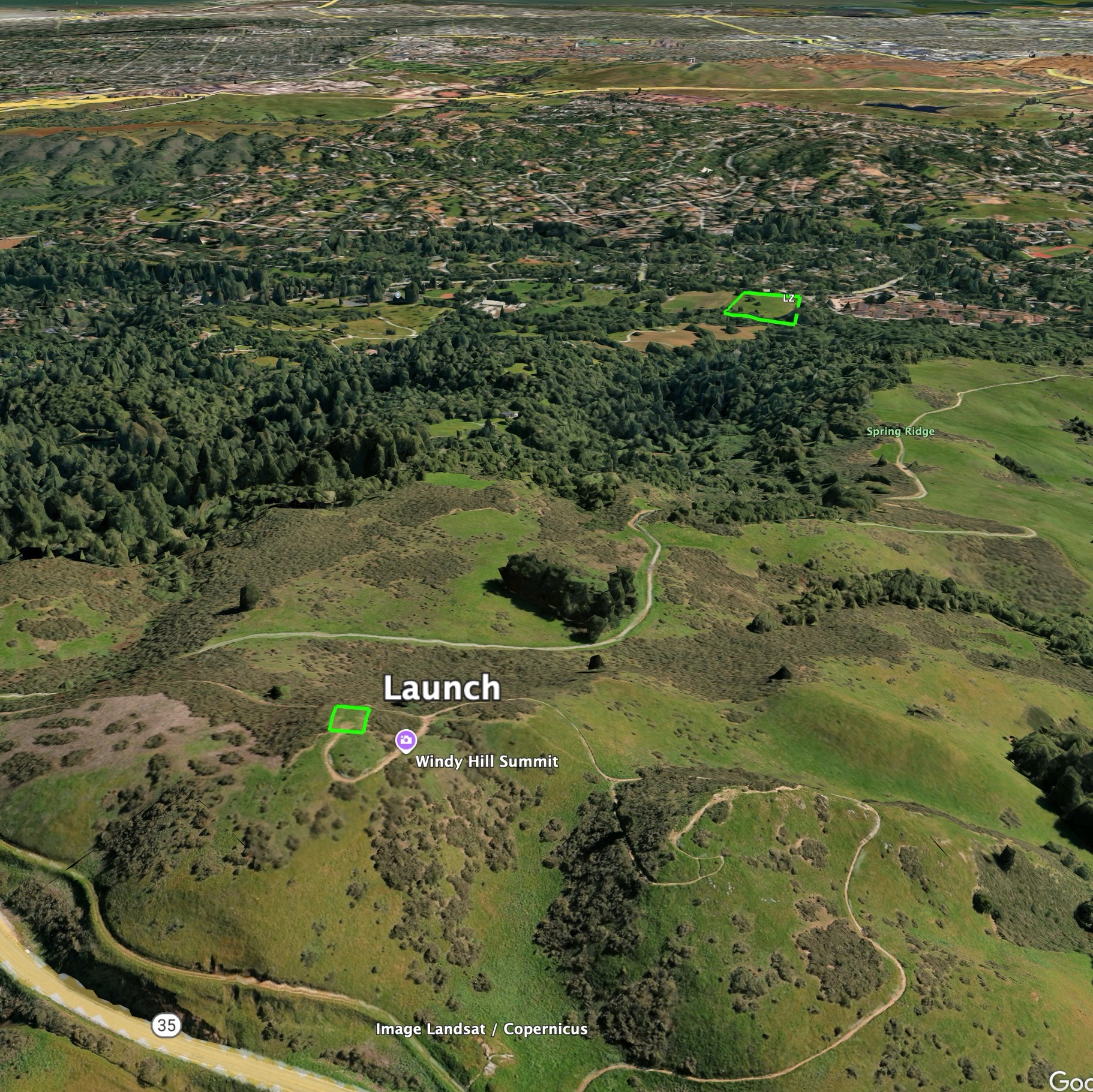
Top landing is permitted if the summit area is clear of people and obstacles, though it is not recommended due to the confined space.


Requirements to Give Site Intros

Pilots giving site introductions should meet these requirements:

  • Must be a Full Member of the Wings of Rogallo
  • Must have flown at Windy Hill for at least one year
  • Must have flown at Windy Hill in a variety of conditions and seasons (e.g. light switchy wind, strong wind, thermic LZ, sinky LZ)
  • Must not have had any suspensions with USHPA or at any Wings of Rogallo sites in the past two years

Tandem flights

Tandem flights are strongly discouraged at Windy Hill due to the long glide to the LZ, frequent challenging flying conditions, and limited size of the LZ.  Tandem flights are only permitted with the explicit permission of the Windy Hill Site Chairperson.


Weather Information

  • Windy Hill is deserving of its name. The launch area is in a large-scale Venturi in the Coast Range, and is subject to significant ridge-top compression
  • Expect the wind speeds at launch to be anywhere up to 5kt stronger than the sensor shows, due to ridge-top compression
  • When the wind is more from the North and is strong, it also tends to be gusty at launch
  • The wind at launch is often much stronger than it is out in front, and there is often a pronounced wind gradient.  Even when the wind is is light at lower elevations, it can be blown out on launch
  • When the wind is strong, conditions are often turbulent, and there will not necessarily be usable lift, particularly if the wind is more Northerly
  • There are a number of freely available and paid weather forecasting tools that can be used to forecast flyable conditions at Windy Hill
  • There is a PG&E-owned weather sensor (station ID: 018PG) close to Windy Hill, about 3km South of the summit along Skyline Road at Russian Ridge Open Space Preserve. It produces somewhat accurate, 10-minute interval temperature, wind, and humidity readings. Its data can be viewed in a number of free tools including Windy